
Here you will find several proposals of trails to travel calmly and enjoy the natural Ourense. If you prefer, in the city there are several associations and groups, such as the one of University of Vigo, which periodically organize trips on foot or by bicycle.
If you wish to continue exploring, the Internet will provide you many alternative routes to discover.
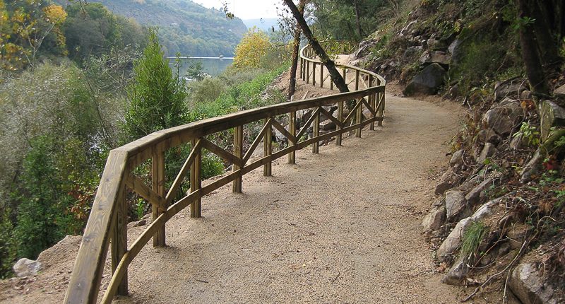
Loña – Santomé River Walk
From the Roman Bridge, follow the course of river Miño along its left bank, upstream, until you reach the mouth of river Lonia. There, turn off to follow the path of this tributary. Upon reaching Mende, next to the school centre, the route continues along an ancient Roman road to the Santomé Archaeological-Natural Site, a beautiful enclave with impressive views over the city that preserves vestiges of Roman and pre-Roman architecture.
Difficulty: easy | Distance: 9 km (circular) | Signposted: no
Open Google MapsRiver Miño’s Walks
From the Roman Bridge, take an underpass to follow the course of the river upstream. Go first to the Loña footbridge (the same spot linking with the route to Santomé) and continue to a second one connecting to the opposite shore, in Oira, where the sports centre and the Nature Hall are located. Follow the route along the north shore and you will see all the historical bridges over the Miño until connecting with the thermal route. Upon reaching Outariz, cross the footbridge to make your way back along the Nymphs’ Lane and the area of Reza.
Along the route you will find playground areas and spaces for physical exercise (calisthenics machines); you can also stop at the thermal areas to enjoy a bath.
Difficulty: easy | Distance: 12.7 km | Route: Circular | Signposted: no
Open Google MapsBarbaña River Walk
The route begins in Puente Lebrón, next to the Os Remedios Sports Centre, following the course of this tributary of river Miño that crosses Ourense from north to south. In its first urban section, the route ends at La Molinera, a new technology centre that was formerly a mill and a power plant wich retains its original chimney. At that point the road forks, and you can continue along river Barbaña to Expourense, returning on the other shore, or continue along the Río dos Muíños (also known as Barbañica) until reaching the city limit with the municipality of Barbadás. In both cases, you can walk the way back on the other shore.
Difficulty: easy | Distance: 10 km | Route: Circular | Signposted: no
Open Google MapsOurense Peri-Urban Trail
Taking the Roman Bridge once again as a reference, it is possible to make a circular route through the green belt that surrounds the city, enjoying nature and discovering villages where it is still possible to witness traditional rural Galician architecture.
Difficulty: medium | Distance: 27 km | Route: Circular | Signposted: partially
More InformationMozarabic Way – From Ourense to Cea
After crossing the Roman Bridge, the pilgrim has two options to continue the Way to Santiago: two beautiful walks that can be walked independently. In the eastern detour, follow Santiago Avenue until you reach an old royal road that will leads you to the village of Cudeiro, where you should visit St. Peter’s Church.
The western detour follows the N-120 road towards Vigo; at the village of Quintela, go to Canedo hill, an intense slope that will reward you with the beautiful landscapes of the Beiro area; there you will also find the interesting Romanesque church of St. Eulalia. You can avoid the road by continuing, from the Bridge, along the Thermal Route. Upon reaching Muíño da Veiga, go through the parking lot to the N-120 road and connect with Quintela.
Both paths meet at the hamlet of Casas Novas, before arriving to Cea. In this town, in addition to enjoying its famous bread, you can take a bus back to Ourense. Along the way you can be guided by the traditional yellow arrows.
Difficulty: medium | Distance: Cudeiro 21 km / Canedo Hill 22 km | Signposted: yes
Open Google MapsMozarabic Way – Arriving to Ourense
The last stage of the Mozarabic Way-Silver Way arriving to Ourense offers an interesting route ideal to cover in one single day, but it can also be divided into several days. You can visit its two variants, both Allariz and Xunqueira de Ambía, towns of great beauty. The variants connect join in Pereiras and enter the city as a single path.
Recommendation: take a bus to either point (check schedules), and follow the enabled signs (yellow arrows). However, you can also do it in reverse, leaving the city through Zamora Avenue and then Seixalbo, where you should stop at the chapel of St. Agatha and enjoy the views.
Difficulty: medium | Distance: 22 km (both variants) | Signposted: yes
Open Google Maps
The presence of thermal waters, great relief for the walker’s feet, together with its strategic situation, have made Ourense a landmark in the Way to Santiago since its inception. Today it is still a must stop on the Mozarabic Way, which is followed by the walkers from southern Spain.
Discover the most natural Ourense, with a landscape defined by its rivers.